Smart Operators Don’t Just Monitor It, They Manage It!
Reliable and up-to-date data on water level and weather is critical to most maritime operations. The data is required in real-time in Vessel Traffic Services (VTS) centres, by pilots and onsite superintendents, and as a historical record for reporting and to update tidal predictions. Often though many organisations find that, while their sensors continue to […]
Read moreAIS Vessel Tracking coming to Port-Log
As part of our Automatic Identification System (AIS) development strategy, we have been trialling an AIS base station to test the reliability of the vessel track and other information collected. The receiver connects directly to a network and reliably supplies live AIS data via a built-in Transmission Control Protocol (TCP) or User Datagram Protocol (UDP) […]
Read more
iCoast – The place to go before you visit Dorset’s spectacular coastline
We are co-sponsoring the further development of the iCoast public website in conjunction with the Dorset Coastal Forum. Originally developed as part of an EU project in 2013 with OceanWise’s digital mapping data, elevation model and tidal data at its core, it is now being updated to ensure it is fit for purpose for the […]
Read moreTeam News
We are pleased to welcome two starters to the OceanWise Team this month, James Rapaport, who joins our Technical Team as Senior Information Systems Developer and, Will Girard, who joins our Customer Service Team as Business Administration Apprentice. James has joined us from Caris, based in New Brunswick, Canada, having previously worked with the OceanWise […]
Read more
Data Management & GIS Workshop
We are hosting our free-to-attend Autumn Marine Data Management and GIS Workshop in London on Tuesday 22nd November at the School of Economic Science, 11 Mandeville Place, London W1U 3AJ. The workshop theme: ‘Is poor data management putting your operations at risk’ is timely given the huge increase in the volume of geospatial and business […]
Read more
Advanced Waves Processing & Display now in Port-Log
Those of you with a keen eye may have noticed new tabs appearing on OceanWise’s Environmental Data Sharing and Publishing platform, Port-Log.net. We have been working hard to improve the way wave data is processed and displayed. New graphics include directional and non-directional wave spectra, as well as time series and tabular displays of key […]
Read more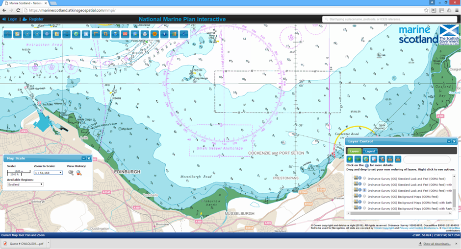
OceanWise data enhances Scottish Government Marine Planning website
Our latest mapping data product, Raster Charts XL (eXcluding Land), has recently been implemented as a background layer within the Scottish Government National Marine Plan interactive (NMPi) website. The NMPi, designed to assist in the development of national and regional marine planning, allows users to examine different types of geographical information online. Links have been […]
Read more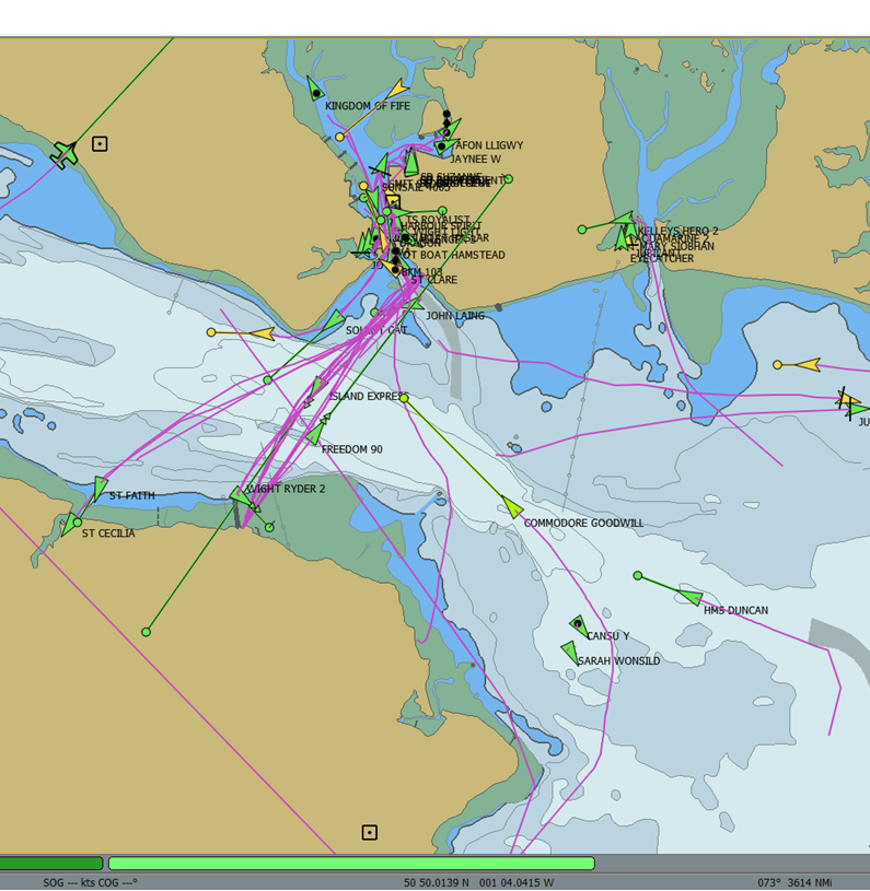
OceanWise rigs up to deliver real-time Vessel Tracking Data to Port-Log
We are currently rigging up to process real-time Automatic Identification System (AIS) vessel tracking data as part of a commitment to extend the functionality of our Environmental Data Sharing and Publishing platform, Port-Log. The data will be used to further enhance the situational awareness provided by the Port-Log interactive map. As part of a pilot […]
Read more
Improving Data Management Guidance for the International Marine Community
In our role as expert contributor and provider of the Secretariat to the International Hydrographic Organisation’s (IHO’s) Marine Spatial Data Infrastructure (MSDI) Working Group, OceanWise has been leading the revision of the IHO Publication “C-17: Spatial Data Infrastructures – The Marine Dimension”. The revised document has now been submitted for approval at the IHO 8th […]
Read more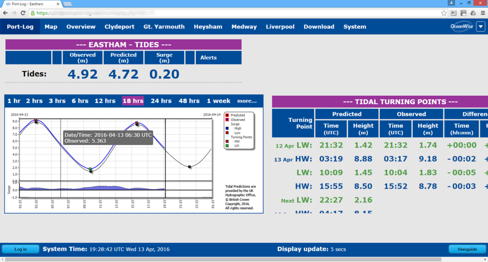
Peel Ports trust OceanWise for New Tide and Weather Data System
Peel Ports has chosen Port-Log, our cloud based Environmental Data Management and Publishing platform, to store and disseminate tide gauge and weather station data across all its ports. Port-Log will acquire data from Peel’s existing network of sensors, using the ip.buffer Smart Telemetry unit. The system also has the capacity to add new types of […]
Read more